Damming Brahmaputra: With mega-dam plans, China might end up hurting itself more than India
The true idea of a river is not of a single stream of water between two banks, but a nervous system of watery arteries and capillaries that form the circulatory system of a living ecosystem in a particular river basin.
At first glance, it looks like another step towards the realisation of an old nightmare for India, and especially for its Northeast. On Sunday, Chinese state media reported that the country’s government had cleared a proposal to begin “hydropower exploitation in the downstream of the Yarlung Tsangpo River” during its next Five-Year Plan period which commences in 2021. Reports spoke of the largest hydropower dam on earth.
The Yarlung Tsangpo is generally identified as the Brahmaputra in India. It flows into Arunachal Pradesh after a long journey through Tibet, and there its name changes to Siang. This then becomes the Brahmaputra when it reaches the plains of Assam.
Anxieties abound in the Brahmaputra Valley of Assam, and in the Siang Valley of Arunachal, about China’s designs on the river depriving these areas of their lifeline. These anxieties have long found resonance with politicians, bureaucrats, engineers and infrastructure companies in the capital cities of Dispur, Itanagar and Delhi.
Any event related to the Brahmaputra, even if it is only a natural one, also gets certain members of India’s strategic affairs community jumping like your favourite loud television anchor on a hot tin roof.
It is a response based on a misconception about the idea of a river.
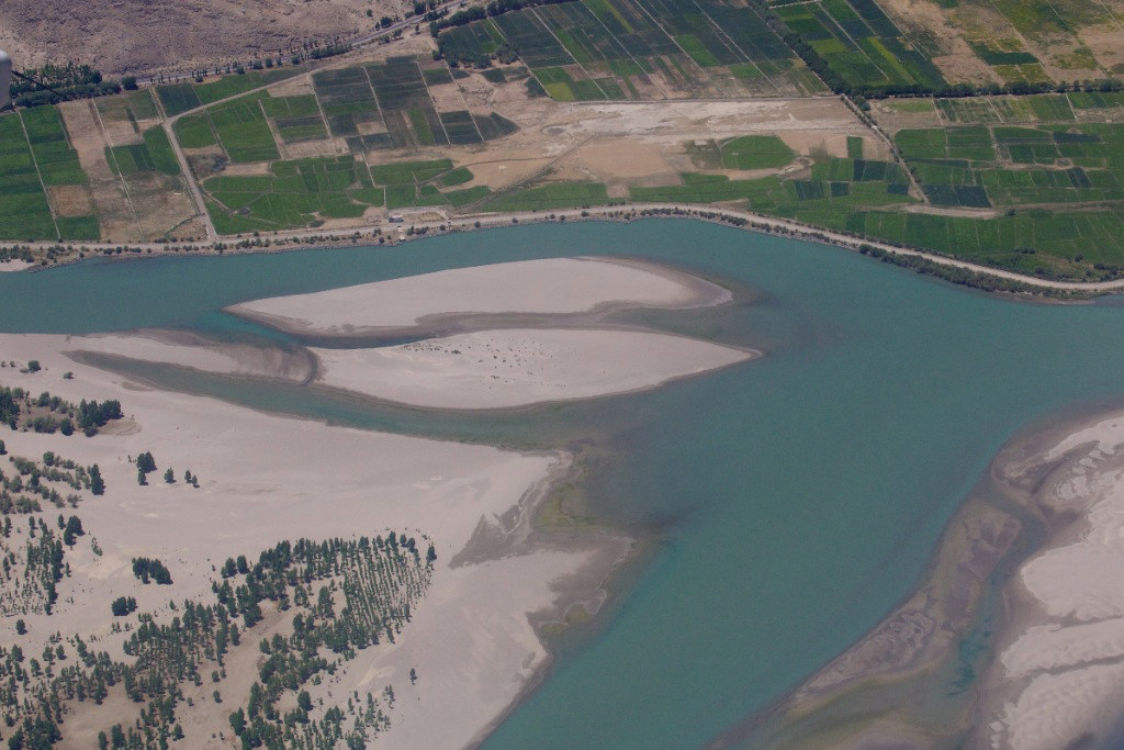
The common image of a river even among journalists and strategic affairs wonks is one that we all drew as children in kindergarten – one channel of water flowing between two banks. After all, if you live in Delhi, the only river you have around you is the sewer and dry river bed that remains of what was once the Yamuna. If you live in Ahmedabad, you’ve seen the canal that was the Sabarmati. If you live in Mumbai, there’s only the Mithi, nearly as mythical as the Saraswati. Guwahati has the Brahmaputra itself, a powerful channel of water between two banks around 1.5 km apart, a perfect illustration of the common idea of the river, and of why that idea is misleading.
Seeing the Brahmaputra almost anywhere else other than Guwahati is a whole other experience. In Upper Assam, around the Dibru Saikhowa national park where it takes the name Brahmaputra with the merging of the Lohit, Dibang and Siang, innumerable braids and streams of water flow into one another. The river there is not a single channel between two banks – it is a shape-shifting network of water that stretches for miles. In monsoon, it can easily expand to over 15 km in width. If you stand on one bank, you cannot see the other.
This river is vastly different from the Yarlung Tsangpo in Tibet, known as the Siang in Arunachal Pradesh, which is merely the longest among its countless tributaries. We can list the big ones – from the Lohit, Dibang and Noa Dihing at the foothills of eastern Arunachal to the Teesta in northern Bangladesh – that flow into the river of many rivers that is the Brahmaputra. However, any such count too is misleading. It’s not only these big tributaries that constitute the Brahmaputra. The true measure of the river’s extent is the “basin”, which is the area of land from which the water flows into a particular river. Every little stream and rivulet in the Brahmaputra basin, from Tibet to Bhutan, Assam, Arunachal Pradesh, Nagaland, Meghalaya and Sikkim, eventually finds its way into the Brahmaputra. They are all part of it.
The true idea of a river therefore is not of a single stream of water between two banks, but a nervous system of watery arteries and capillaries that form the circulatory system of a living ecosystem in a particular river basin.
A mapmaking convention developed to designate the longest tributary of a river as the river itself. Thus, the Yarlung Tsangpo came to be identified with the Brahmaputra in British colonial times, when Northeast India’s first maps were drawn. But the Tsangpo is not the Brahmaputra; it has barely 1/20th of the water of the Brahmaputra measured after the Brahmaputra receives the Teesta’s waters.
The Chinese cannot steal the whole Brahmaputra even if they wish, for the simple reason that it does not flow there. The myriad channels that feed it are mostly streams that flow on the southern, Indian side of the Himalayan watershed. The McMahon Line that forms the disputed boundary between India and China in Arunachal Pradesh largely follows this watershed. It is the natural dividing line in the high mountains where the waters part, with all the water on the southern slopes flowing south, and all of that on the northern side flowing north.
Chinese plans of exploiting the hydropower potential of the Tsangpo are not new. They have been in the public domain for a decade at least. Engineers there have long viewed the river’s “Grand Canyon” area around what is called the “Great Bend” with greedy eyes. In that area, the Tsangpo rapidly descends two kilometers through a narrow gorge in the remote east of Tibet. They reckon that a dam on the river near the Great Bend could generate more power than the 22,500 MW generated by the Three Gorges Dam, which is now the biggest hydropower dam in the world.
They may well be correct in this estimate, but there are multiple factors to consider even from a purely engineering point of view. This year, during the monsoon rains, the Chinese state-run media – no less nationalistic than sections of our ‘free’ press – was compelled to publish a series of articles praising the Three Gorges Dam, because devastating floods were affecting tens of millions of people, and fears that the dam itself might collapse.
The risks of a catastrophic dam burst are higher in the fragile, earthquake-prone Himalayan topography.
The structures themselves are subject to wear and tear. After fifty years, the dam will not be as strong, while the rivers and floods may well be stronger. Nor is a large dam the only way to tap hydroelectric potential at the Great Bend; that can be done quite easily using a “run of the river” hydroelectric project, which would only require diverting a part of the water through turbines before releasing it back into the river.
Just as the river is not a mere channel of water between two banks, it is also not only a “water resource”. It is a complex, living, organic system. India as the downstream riparian will no doubt suffer if China dams the river upstream, but China itself may suffer more. The Brahmaputra, and even the Siang, will however survive such short-sightedness.
The true blunder will be if Chinese actions provoke similar moves on this side of the border – that would be suicidal, perhaps in more ways than one.
This article was first published in Firstpost in Joining the Dots, a weekly column by author and journalist Samrat in which he connects events to ideas, often through analysis, but occasionally through satire. This has been published with author permission.

